Structure of the Atmosphere Meteorology is the study of the atmosphere- including weather. Weather is the condition of the atmosphere. It can change from time to time and place to place. Climate is the type of weather an area has over a long period of time.
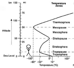
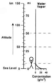
Layers of the atmosphere: separated by the variation of temperature patterns.
In these two models, you can see how most of the atmosphere is concentrated near the surface due to the pull of gravity.
Troposphere
We live in the troposphere.
0-18 km
Gets colder as you go up.
All weather occurs here
"The Troublesphere”
All water vapor in the atmosphere is here
Stratosphere
Temperatures get warmer as you go up.
Home of the Ozone layer.
Mesosphere & Thermosphere
Upper layers of the atmosphere.
The air is very thin here.
Atmospheric Variables- things that can be measured and change from moment to moment.
(Click the link to go down to that section)
Average Kinetic Energy- kinetic energy is the energy of motion.
The slower the molecules vibrate, the colder the material.
If they vibrate fast, it is hot.
Mix hot & cold and you get warm.
The hot molecules still move fast and the
cold move slow.
But the temperature averages to warm.
The temperature of any material is an average of all of the kinetic energies- hence Average Kinetic Energy.
3 ways to Measure temperature: Fahrenheit
Water freezes at 32°
Water boils at 212 °
Celsius
AKA Centigrade (100 levels)
Water freezes at 0 °
Water boils at 100 °
Makes more sense and is easier to make a thermometer
Kelvin
Same scale as Celsius but 0 means zero energy
No degrees mark for Kelvin
0K means that all atomic vibrations stop.
Youtube video showing how to make a homemade thermometer.
Converting Temperature
To convert °C into °F: °F = °C x1.8 + 32
To convert °F into °C: °C = (°F - 32) ÷ 1.8
To convert °C into Kelvin K = °C + 273.15
To convert K into °C: °C = K -273.15
Energy always go from high to low.
There is no such thing as “cold”.
Cold is just an absence of heat.
Ice doesn’t add cold to something.
It sucks the heat into it.
Heat flows from hot to cold
(source to sink).
Heat Transfers: Radiation -the transfer of heat in the form of light.
The Greenhouse Effect
IR (infrared) light that is re-radiated from the ground is stopped from reaching space by extra “greenhouse gasses” in the air.
CO2 from burning fossil fuels.
Clearing of trees.
Fart gas from cows (methane).
Conduction- Heat transfers from one object to another through touch.
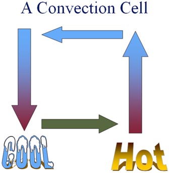
Convection
Hot Rises
Cold Sinks
Caused by density differences:
Hot air expands and gets less dense.
Cold air contracts and gets more dense.
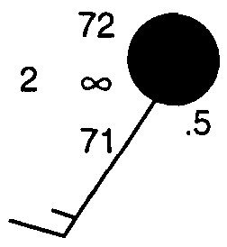
Air Pressure
The weight of the air above you. The more air that is above you the more pressure you will feel.
Sinking air pushes down more- cold air is usually high pressure.
Rising air pushes down less- hot air is usually low pressure.
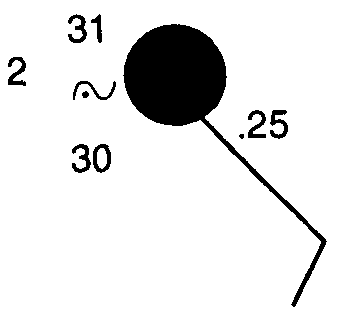
When converting from millibars to station model code, use only the last three digits and throw out the decimal point.
When converting from station model code to millibars:
Write your code twice
Write a 10 in front of one
and a 9 in front of the other
Insert the decimal point between the last two numbers
Look on the reference Tables so see which one is possible
(Short Method: if the code is 500 or higher put a 9 in front, therwise put a 10)
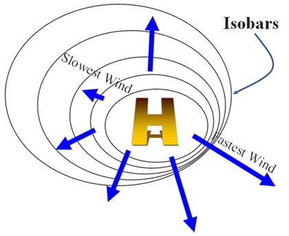
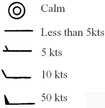
Wind
Wind travels from high pressure to low.
The gradient between isobars determines the wind speed.
Big Difference in Pressure
(Steep Gradient) = fast wind Small Difference in Pressure
(Gentle Gradient) = gentle winds
The Coriolis Effect
The Coriolis Effect deflects things to their right in the Northern Hemisphere.
Caused by the rotation of the Earth.
High Pressure flows outward and clockwise (cw) (in the N. Hemisphere)
Low Pressure flows inward and counterclockwise (ccw)(in the N. Hemisphere)
The Right Hand Rule
Your thumb (of your right hand) represents the rising or sinking of low or high pressure.
Your fingers wrap around your palm the way that the wind spirals around the pressure system.
Low Pressure sucks so low has inward flow while highs are outward.
Wind Direction
Winds are named for the direction that they come from
On a map direction is shown with a line showing where it came from.
Southeast wind
Northwest wind
Northeast wind
Southwest wind
Wind Speed
Water Content & Humidity
The amount of water in the air is called humidity. The actual amount of water vapor in the air is the absolute humidity.
The ability of air to hold water changes depending on the temperature.
Relative humidity tells "how full" the air is with water.
It is expressed in %.
100% is full and can't hold any more.
It is saturated.
Water gets into the air by evaporation or sublimation.
Evaporation is changing from a liquid to a gas.
Sublimation is changing from a solid (snow or ice) to a gas. (sublime means to skip a step)
To get the water out of the air it either condenses or sublimes.
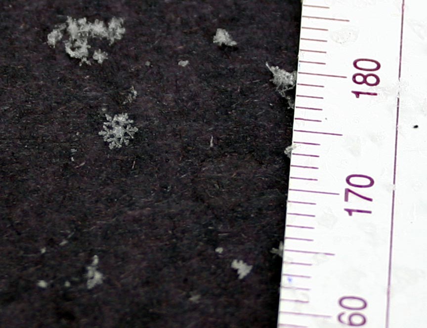
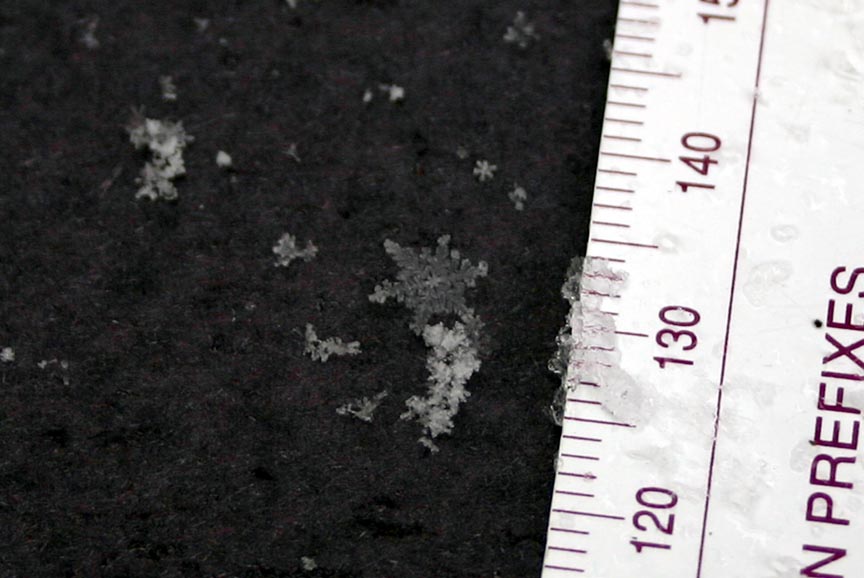
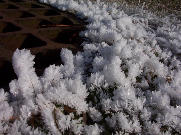
Two images of snow.now is not frozen rain. It is an ice crystal that forms directly from
water vapor by the process of sublimation.
Photos by Phil Medina, Stony Brook, NY 2005
(Right-click to view the full sized pictures)
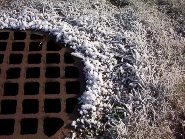
These two images show frost forming from water vapor coming out of a warm sewer drain.
Photos by Phil Medina, Yaphank, NY 2004
condense-changing from gas to liquid.- dew
Condensation nucleus – a small piece of dust, smoke, or salt that acts as a surface for codensation.
precipitation- water that condenses in the atmosphere falls to the surface.
Precipitation cleans out the atmosphere by pulling down the condensation nuclei (pollution)
Measuring Relative Humidity
The “Dry Bulb”
Don’t let it fool you. It is just a thermometer.
It measures the air temperature.
Duh!
The “Wet Bulb”
Has a little wet booty tied to the bottom.
Gets cool when water evaporates.
On A Dry Day...
A lot of moisture will evaporate.
The wet bulb will be a lot cooler than the dry bulb.
On A Humid Day...
A little bit of moisture will evaporate.
The wet bulb will not be much cooler than the dry bulb.
Storms
Cyclone- any inward and counterclockwise air circulation around a low pressure center.
Types of Cyclones:
Tornado
a small, compact storm with strong winds.
AKA:
Twister
Willy-Willy (Australia)
Extremely localized low pressure center.
99.9% in Northern Hemisphere spin ccw.
Come from strong thunderstorms.
Can be predicted a few minutes early with Doppler radar.
Fujita Scale is based on the width and wind speed of the funnel.
A large, organized storm with strong winds and heavy rain.
AKA
Typhoon- in the Pacific
Massive storms with a size that can be more than 300 miles in diameter.
Feed on warm water.
Biggest danger is the storm surge in coastal areas.
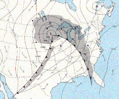
Mid Lattitude Low
a low pressure system in the middle latitudes.
We live in the middle latitudes.
Comma-shaped ,
AKA
Nor’ Easter (North Easter)
Alberta Clipper
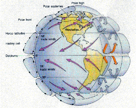
Prevailing Winds
Push weather around
On LI, the prevailing winds come from the west.
Most of the time our winds come from the west.
Therefore our weather will usually come from the west.
Prevailing Westerlies- the typical west wind in most of the United States.
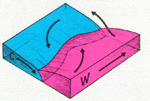
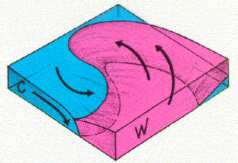
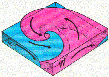
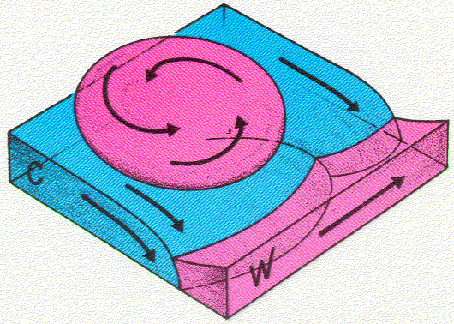
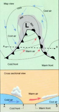
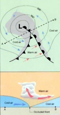
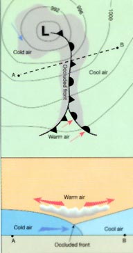
Development of The Mid Latitude Low
This weather system starts when cool and warm air masses meet.
Then a Low develops over the interface.
The Low continues to spin, creating a warm front and a cold front.
As the air masses mix, the fronts overlap in the center creating an occluded front.
In the end, the air mixes and the system breaks down.
Rain will fall in front of the warm front and right on top of the cold front.
A well-developed Mid-Latitude Low
Fronts
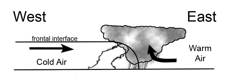
The Cold Front
Moves faster than the warm.
Rain falls on top of the front.
Short period of heavy rain & maybe thunder
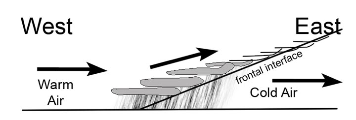
The Warm Front
Moves slower
The rain falls in front of the front
Gentle rain for a long period of time.
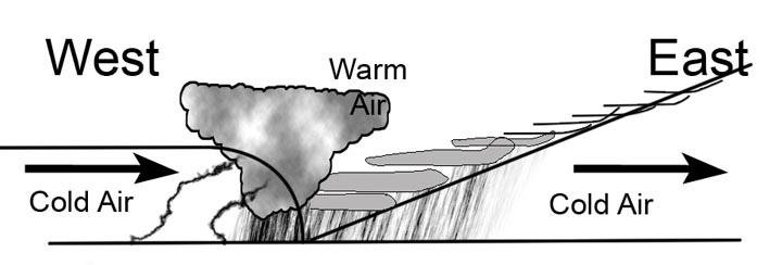
The Occluded Front
Combination of warm front and then cold front
A long period of gentle rain followed by heavy rain & possibly a t-storm
Fronts
A front is the leading edge of an air mass.
If it is the front of a cooler air mass, it will be a COLD FRONT.
If it is the front of a warmer air mass, it will be a WARM FRONT.
How to tell where a front belongs on a map.
A front will be located where the temperature changes rapidly in a short distance.
Isotherms will be close together.
How to tell what kind of front it is.
It depends on which direction the front is moving…Look at the winds on both sides of the front.
On one side, the winds will be “pushing” the front.
On the other side, the winds will be retreating from the front.
If colder air is coming in, it is a cold front.
If warmer air is coming in, it is a warm front.
Climate Factors
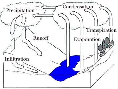
The Water Cycle
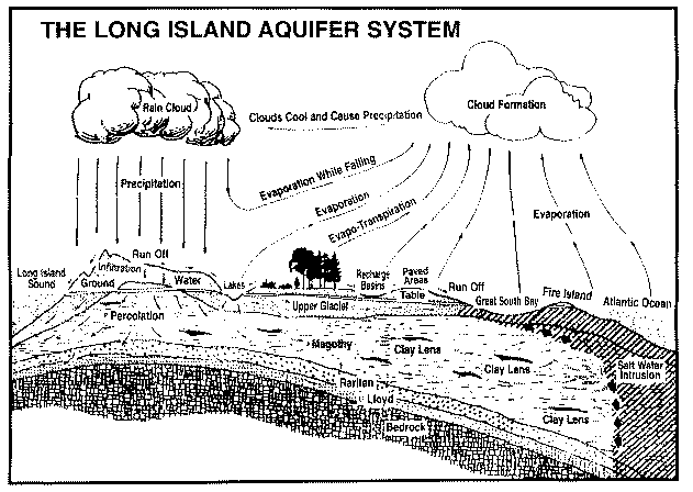
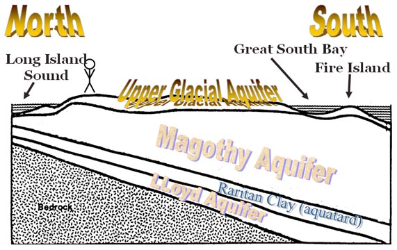
On Long Island, this is how it all comes together:
Ground water
When water hits the ground there are a few things that the water can do. It can evaporate, collect, runoff or infiltrate.
When water collects on the surface of the land it produces standing water, puddles, ponds or lakes. Runoff is the term for water that slides over the surface looking for the lowest points around- in other words: rivers.
Infiltration is the process that lets water get into the ground. The amount and rate of infiltration depends on how much space there is inside the ground and how well the spaces are connected. Water that seeps into the ground fills in spaces between the sediments called pores.
Porosity is a measure of the percentage of the rock material that is made of empty spaces and is calculated with the equation:
Porosity can be affected by the sediment’s shape, sorting and packing.
GRAPHIC: Fig 8-2 large spheres & Fig 8-8 impermeable angles **TWO GRAPHICS SIDE-BY-SIDE**
Caption: The spherical shapes on the left and the irregular shapes on the right affect the soil’s porosity.
GRAPHIC: Fig 8-2 large spheres & Fig 8-3 mixed spheres **TWO GRAPHICS SIDE-BY-SIDE**
Caption: The sorted soil on the left has a higher porosity than the mixed sediments on the right.
GRAPHIC: Fig 8-7 loose spheres & Fig 8-6 packed spheres **TWO GRAPHICS SIDE-BY-SIDE**
Caption: The packing affects the amount of pore space.
One thing that does not affect porosity is the size of the particles. Imagine sediments made of spheres. The ratio of solid material compared to the spaces between them will stay the same regardless of the size of the spheres. Smaller particles will have smaller pores but a lot more of them. Large sediments have few spaces but the spaces take up a large volume.
GRAPHIC: Fig 8-2 large spheres, Fig 8-4 medium spheres & Fig 8-5 small spheres
**THREE GRAPHICS SIDE-BY-SIDE**
Caption: The ratio of sediment to empty pore space is the same in all three diagrams.
Another factor to consider when explaining how much water will infiltrate into the ground is the ability of water to penetrate into the soil. Even though porosity is a major factor, the pores must be connected to allow flow. The ability of water to flow through rock or soil is called permeability (the ability to permeate). Just because a material has a high porosity does not automatically mean that it has a high permeability. Volcanic pumice is a prime example of a rock with high porosity but low permeability. Pumice is a bubbly rock made mostly of gas pockets trapped within the rock. Pumice floats! It floats because the gas pockets are completely sealed and act as little life preservers. The same feature that allows pumice to float also forbids water from permeating the rock: the chambers are sealed and the water cannot penetrate. Conversely, some very solid, non-porous igneous rocks can have a high permeability. This is accomplished if the rock is fractured which may provide channels for the water to flow through. (This is sometimes cited as a cause of water levels changing shortly before earthquakes. The stress from the impending quake fractures bedrock and allows groundwater to redistribute.)
GRAPHIC: Fig 8-8 impermeable angles & Fig 8-9 permeable angles
**TWO GRAPHICS SIDE-BY-SIDE**
Caption: The sample on the left has a very low permeability because the pores are not lined up. In the sample on the right, the water easily and quickly flows through the sediments.
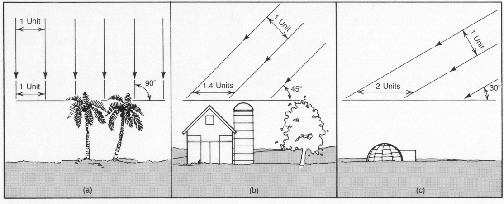
Angle of Insolation
Insolation is energy from sunlight. Incoming Solar Radiation. The strength of insolation depends on the angle at which the light hits the ground.
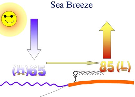
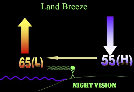
Land Breeze-Sea Breeze
Water is stubborn.
It does not want to change its temperature.
It has a high specific heat.
During the day, the land will heat up more than the water and will create a convection current.
At night , the land will coll down faster than the water and will create a convection current in the opposite direction.
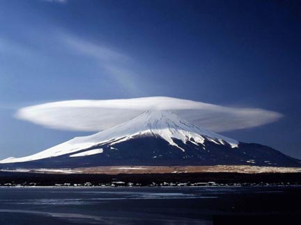
Orographic Effect (Mountian Barrier)
When air is forced to rise because it hits mountains, it will cool and condense.
On the Windward side of the mountains it will have a moist climate.
On the Leeward side, there will be a dry climate that is usually warmer than the windward
(Caused by the release of heat during the condensation on the windward)
Temperature Time Lag
Since it takes a little time for the atmosphere to heat up, the hottest time of the day is around 2 pm.
Since it takes so long for the oceans to heat up, the hottest time of the year is July/August.